The Rephidim Spring produced when Moses struck the Rock in Horeb is at the Sadd Al Khanaq dam in Medina

Watch the whole Youtube video “Exodus route 2 - Locating Mount Sinai, the Desert of Sin, Rephidim & the Desert of Paran”.
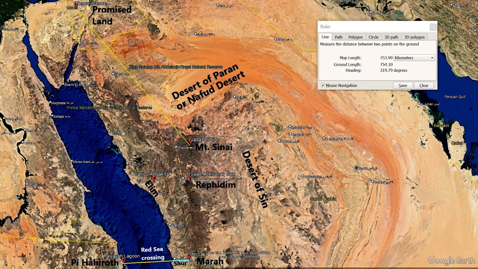
Exodus 17: 1 The whole Israelite community set out from the Desert of Sin, traveling from place to place as the Lord commanded. They camped at Rephidim.
Rephidim was where Moses struck a rock and caused water to come out, that was enough to quench the thirst of perhaps more than a million Israelites. He called the source of this spring “Massah and Meribah” - see Exodus 17: 1-7. Located 151 kilometers northeast of Yanbu Al-Nakhal (or the Biblical Elim) and at the east side of the mountain range (or the Desert of Sin) is found an ancient dam named Sadd Al-Khanaq. It stretches across a tight corridor between two mountains. Its height of 17 meters coincides with the height of the two mountains that encase the dam, while its length is “limited” to 43 meters thanks to two protruding cliffs on both sides of the valley that form two natural shoulders providing a solid foundation for the wall structure at both ends. Its width reached 17 meters at the base and only 12.7 meters at the top.
A Kufic inscription dating from the time of its construction designates the Umayyad Caliph Mu’awiyah bin Abi Sufyan (who reigned between 661 and 679 AD) as the sponsor of this dam. Obviously, this dam was built long after the time of Moses. A spring of water flowed freely and profusely when Moses struck a rock on top of its source with his rod. This implies that the rock was blocking the flow of water. If the source of this ancient spring was the same as the source of the water in the Sadd Al-Khanaq dam, then a boulder no wider than 12.7 meters was enough to block the flow of its water. Furthermore, the two mountains encasing this spring tightly may have been what Moses was referring to when he named the place “Massah and Meribah”.
The Sadd Al-Khanaq dam is located just 15 km east of Medina. Now let me tell you why this is important. The Hebrew text for Midian is Mem Dalet Yod Nun and is currently pronounced as Midian with the Yod used as consonant. However, if Hiriq is written in the consonant preceding Yod, which in this case is the Dalet, the Yod is used as the vowel i with a long ee sound like the “i” in Medina. And since vowels and niqqud marks were not written in the original Bible transcript, Mem Dalet Yod Nun could have been pronounced as Medina during Moses’ time instead. And this explains why while the Israelites were in Rephidim, Jethro priest of Midian (or should I say Medina), visited Moses - see Exodus 18.
Exodus 19: 1-2, 18 On the first day of the third month after the Israelites left Egypt—on that very day—they came to the Desert of Sinai. After they set out from Rephidim, they entered the Desert of Sinai, and Israel camped there in the desert in front of the mountain…
Mount Sinai was covered with smoke, because the Lord descended on it in fire. The smoke billowed up from it like smoke from a furnace, and the whole mountain trembled violently.
Setting out from Rephidim and coming to the Desert of Sinai implies Rephidim was yet a distance away from Sinai (which was also called Horeb in parallel Biblical accounts). But why did Exodus 17: 6 say that Moses struck the rock in “Horeb” while they were still in Rephidim? The literal meaning of “horeb” is desert, and it is related to the Hebrew word khaw-rab' which means destroyed. Horeb is also thought to mean glowing/heat. And this made me conclude that “the rock in horeb” actually referred to a volcanic rock or boulder that was still glowing hot while on top of the source of a spring preventing its flow. Most definitely, it doesn’t mean that the “rock in horeb” which Moses struck was in Mount Sinai. It only meant that one or both of the two mountains named “Massah and Meribah” and on opposite sides of the “rock in horeb” in Rephidim were volcanoes.

Comments
Post a Comment