Exodus route 2 - Locating Mount Sinai, the Desert of Sin, Rephidim & the Desert of Paran
This is the transcript to my Youtube video with the same title.
In my previous video titled “Exodus route 1 Locating the Red sea crossing, Pi Hahiroth, Migdol, Baal Zephon, Shur, Marah, & Elim'', I identified Pi Hahiroth which is translated by the Strong’s concordance as both “mouth of the gorges'' or "place where sedge grows'' as the Rawayah Lagoon in the middle of Dungunab Bay. I identified Migdol, which the Strong’s concordance translates as “tower” or a fortified city on the Egyptian border, as Semna, a fortified city founded during the Twelfth Dynasty of Egypt in the area of Lower Nubia.
I identified Baal Zephon, translated by Strong’s concordance as "lord of the north", as the idol of the storm and rain god Hubal inside the Kaaba in Mecca. I identified the desert of Shur as the southeast desert road from Jeddah towards Marwa in Mecca. I identified the Biblical Marah as Marwah near where the well named Zamzam in Mecca is located. Finally I identified Elim where there were twelve springs and seventy palm trees as a place in Saudi Arabia called Yanbu Al-Nakhal (which literally means “the spring of the palms”).
Exodus 16: 1 The whole Israelite community set out from Elim and came to the Desert of Sin, which is between Elim and Sinai.
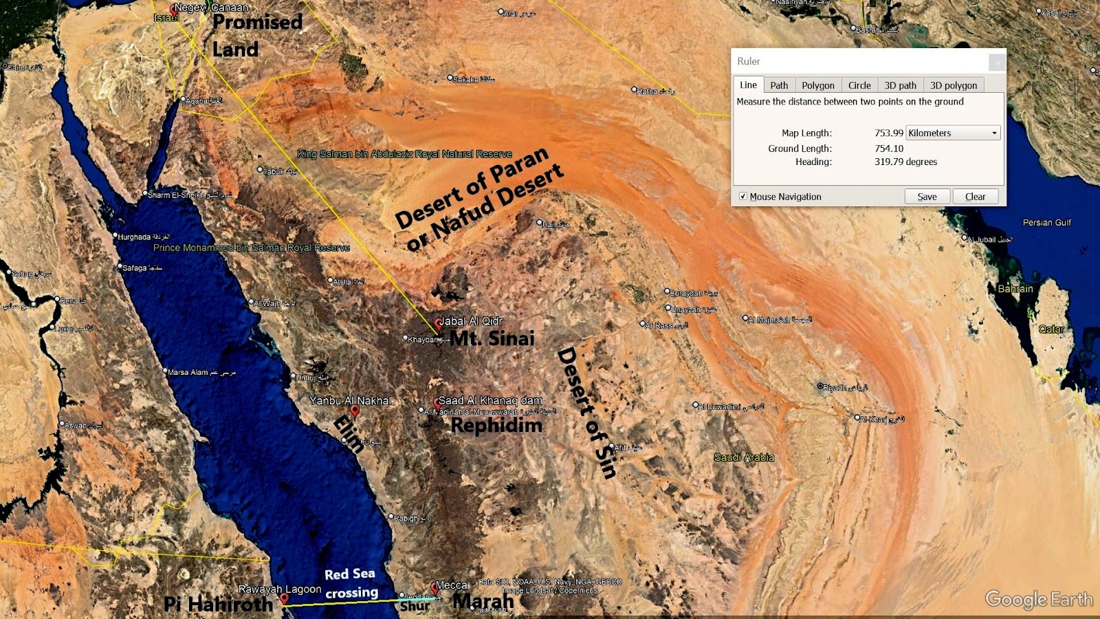
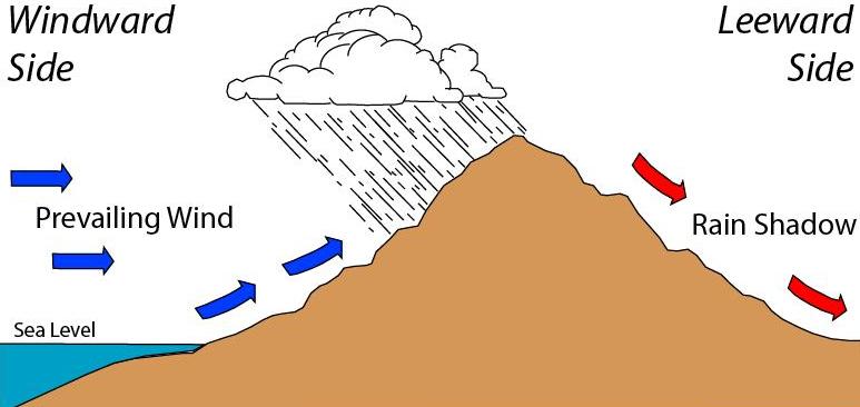
To identify the Desert of Sin properly, one needs to know about rain shadows. A rain shadow is a patch of land that has been forced to become a desert because mountain ranges blocked rainy weather. On one side of the mountain, wet weather systems drop rain and snow. On the other side of the mountain, the rain shadow side, all that precipitation is blocked. In the case of Yanbu, bordered in the west by the Red Sea and bordered in the east by a mountain range, this side is where wet weather systems drop rain, therefore forming an oasis. On the east side of the mountain range is the rain shadow where all precipitation is blocked. This eastern side is where the Desert of Sin is located, and where the God of Israel first rained down manna, the bread from heaven - see Exodus 16.
Exodus 17: 1 The whole Israelite community set out from the Desert of Sin, traveling from place to place as the Lord commanded. They camped at Rephidim.
Rephidim was where Moses struck a rock and caused water to come out, that was enough to quench the thirst of perhaps more than a million Israelites. He called the source of this spring “Massah and Meribah” - see Exodus 17: 1-7. Located 151 kilometers northeast of Yanbu Al-Nakhal (or the Biblical Elim) and at the east side of the mountain range (or the Desert of Sin) is found an ancient dam named Sadd Al-Khanaq. It stretches across a tight corridor between two mountains. Its height of 17 meters coincides with the height of the two mountains that encase the dam, while its length is “limited” to 43 meters thanks to two protruding cliffs on both sides of the valley that form two natural shoulders providing a solid foundation for the wall structure at both ends. Its width reached 17 meters at the base and only 12.7 meters at the top.
A Kufic inscription dating from the time of its construction designates the Umayyad Caliph Mu’awiyah bin Abi Sufyan (who reigned between 661 and 679 AD) as the sponsor of this dam. Obviously, this dam was built long after the time of Moses. A spring of water flowed freely and profusely when Moses struck a rock on top of its source with his rod. This implies that the rock was blocking the flow of water. If the source of this ancient spring was the same as the source of the water in the Sadd Al-Khanaq dam, then a boulder no wider than 12.7 meters was enough to block the flow of its water. Furthermore, the two mountains encasing this spring tightly may have been what Moses was referring to when he named the place “Massah and Meribah”.
The Sadd Al-Khanaq dam is located just 15 km east of Medina. Now let me tell you why this is important. The Hebrew text for Midian is Mem Dalet Yod Nun and is currently pronounced as Midian with the Yod used as consonant. However, if Hiriq is written in the consonant preceding Yod, which in this case is the Dalet, the Yod is used as the vowel i with a long ee sound like the “i” in Medina. And since vowels and niqqud marks were not written in the original Bible transcript, Mem Dalet Yod Nun could have been pronounced as Medina during Moses’ time instead. And this explains why while the Israelites were in Rephidim, Jethro priest of Midian (or should I say Medina), visited Moses - see Exodus 18.
Exodus 19: 1-2, 18 On the first day of the third month after the Israelites left Egypt—on that very day—they came to the Desert of Sinai. After they set out from Rephidim, they entered the Desert of Sinai, and Israel camped there in the desert in front of the mountain…
Mount Sinai was covered with smoke, because the Lord descended on it in fire. The smoke billowed up from it like smoke from a furnace, and the whole mountain trembled violently.
Setting out from Rephidim and coming to the Desert of Sinai implies Rephidim was yet a distance away from Sinai (which was also called Horeb in parallel Biblical accounts). But why did Exodus 17: 6 say that Moses struck the rock in “Horeb” while they were still in Rephidim? The literal meaning of “horeb” is desert, and it is related to the Hebrew word khaw-rab' which means destroyed. Horeb is also thought to mean glowing/heat. And this made me conclude that “the rock in horeb” actually referred to a volcanic rock or boulder that was still glowing hot while on top of the source of a spring preventing its flow. Most definitely, it doesn’t mean that the “rock in horeb” which Moses struck was in Mount Sinai. It only meant that one or both of the two mountains named “Massah and Meribah” and on opposite sides of the “rock in horeb” in Rephidim were volcanoes.
A suggested possible naturalistic explanation by many scholars about the Biblical devouring fire seen in Sinai is that it could have been an erupting volcano, and I totally agree. Ḥarrat Khaybar is a volcanic field located north of Medina in the Hejaz, Saudi Arabia. It covers an area approximately 12,000 square kilometers. There were 603,550 men over 20 years old at the time of the Exodus. That probably would mean at least half a million family units, each including a wife and a couple of children, for a total of two million in the camp. And that is likely a conservative estimate. Each family seemingly had a small flock of sheep and other animals used to transport their stuff. Their camp may easily have occupied over 1000 square miles or over 2,590 square kilometers. Clearly, the Harrat Khaybar volcanic field is more than large enough to accommodate the camping Israelites and their flocks, unlike the Sinai Peninsula.
There are three main volcanoes in this volcanic field: the two White Mountains of Harrat Khaybar named Jabal Abyad and Jabal Bayda, which derive their light appearance from comendite. Jabal Abyad, at an elevation of 2,093 meters, is the tallest volcano in Saudi Arabia. These mountains contrast with the darker appearance of the hawaiite lava flows and domes which dominate the lava fields of the third volcano Jabal Qidr. Anyone of these three volcanoes could have been “The Mount Sinai”, but I am biased towards Jabal Qidr which has a darker appearance and whose name in Arabic translates to “mountain pot” emphasizing its active volcano status.
It is estimated that the Israelites camped near Mount Sinai for almost a year. More than a million people camping near Mount Sinai for almost a year surely means there must be evidence of their sojourn there. And indeed there are, and quite plenty of them!
livescience.com, 400 Mysterious Ancient Stone Structures Discovered in Saudi Arabia by Owen Jarus published October 17, 2017: Almost 400 mysterious stone structures dating back thousands of years have been discovered in Saudi Arabia. Many of the stone walls, which archaeologists call "gates" because they resemble field gates from above, were found in clusters in a region in west-central Saudi Arabia called Harrat Khaybar. The smallest of the gates extends about 13 meters, while the longest is 518 m long, or longer than an NFL football field. Many have multiple stone walls that, in some instances, form a rectangular design; some of the others, called "I" type gates, have only one stone wall with heaps of stone at each end.
According to those who discovered these structures, "no obvious explanation of their purpose can be discerned." I beg to disagree. The rectangular gates are obviously animal pens which the millions of Israelites during the Exodus used to protect and control their livestock. The “I” type gates were limits or barricades erected to prevent the Israelites from approaching the foot of Mount Sinai:
Exodus 19: 12 Put limits to the people around the mountain and tell them, ‘Be careful that you do not approach the mountain or touch the foot of it. Whoever touches the mountain is to be put to death.
After Mount Sinai, the next station of the Exodus was the Desert of Paran:
Numbers 10: 11-12 On the twentieth day of the second month of the second year, the cloud lifted from above the tabernacle of the covenant law. Then the Israelites set out from the Desert of Sinai and traveled from place to place until the cloud came to rest in the Desert of Paran.
The Nafud desert is a desert in the northern part of the Arabian Peninsula. Located northwest from Harrat Khaybar (which I identified as the desert of Mount Sinai) is the land of Canaan (or the Promised land), and the vast Nafud desert is what separates them by a distance of approximately 754 kilometers. Desert kites are dry stone wall structures found in Southwest Asia (Middle East, but also North Africa, Central Asia and Arabia), which were first discovered from the air during the 1920s. There are over 6,000 known desert kites, with sizes ranging from less than a hundred meters to several kilometers. Little is known about their ages, but the few dated examples appear to span the entire Holocene which is the current geological epoch which began approximately 11,700 years ago.
Archaeological studies and ethnographic accounts indicate that desert kites in the Middle East and North Africa were used as traps for wild game. A minority viewpoint is that they were used for livestock management. I believe they may be stone walls erected to protect (from wild animals of the Arabian peninsula) small groups of Israeli families camping together during the Exodus. If one looks at the distribution of different kite types across the Arabian Peninsula, one can see that it follows the exact Exodus route which I discussed.
Note also that the largest number of kites were built in the Al Labbah plateau in the Nafud desert (which I believe to be the Desert of Paran). This is where the Israelis of the Exodus spent 40 years wandering in the wilderness. The distribution of “kites” (human camp stone walls) and “gates” (livestock stone pens) in Harrat Khaybar (or the Sinai desert) shows that kites outnumber the gates, confirming my conclusion that the gates were for livestock while the kites were for humans. Furthermore, these gates surround only Jabal Qidr, one of three volcanoes in Harrat Khaybar volcanic field, implying that Jabal Qidr was indeed Mount Sinai, the mountain of God.

Comments
Post a Comment