Exodus route 1 Locating the Red sea crossing, Pi Hahiroth, Migdol, Baal Zephon, Shur, Marah, & Elim
Most mainstream scholars do not accept the Biblical Exodus account as history for a number of reasons and this is why they refer to it as the founding myth of the Israelites. One of the reasons given was the Book of Numbers’ claim that the number of Israelite males aged 20 years and older in the desert during the wandering were 603,550, including 22,273 first-borns, which modern estimates put at 2.5-3 million total Israelites. According to scholars this vast number could not be supported by the Sinai Desert through natural means.
In this video, I will show that the Exodus route did not pass the Sinai Peninsula at all. Also, in my previous video titled “The Pharaoh & Queen of the Exodus were Amenemhat IV & Sobekneferu of the 12th Dynasty of Egypt!” I identified the 12th Dynasty as the period when the Exodus happened. One important reason why the Exodus route could not have passed in the Sinai Peninsula or anywhere near it is because during the 12th Dynasty, its rulers were certainly aware of the need to control the flow of people into their country as can be read from the “Prophecy of Neferti” - attributed to an individual named Neferyt, who most likely composed it at the beginning of the Twelfth Dynasty. It reads: "Asiatics who roam the land. Foes have risen in the East, Asiatics have come down to Egypt."
Along the Eastern Delta, Amenemhat I (the 1st king of the 12th Dynasty) began the construction of the Walls of the Prince, a string of fortresses on the eastern border of the Delta. The Prophecy of Neferti: "One will build the Walls-of-the-Ruler, To bar Asiatics from entering Egypt; They shall beg water as supplicants, So as to let their cattle drink. Then Order will return to its seat, While Chaos is driven away."
According to the table of nations in Genesis 10: 6-14 Egypt, son of Ham, was the father of the Kasluhites (from whom the Philistines came). This explains why at its maximum territorial expansion, Philistia’s territory may have stretched along the Canaanite coast from Arish in the Sinai (today's Egypt) to the Yarkon River (today's Tel Aviv).
Exodus 13: 17-18 When Pharaoh let the people go, God did not lead them on the road through the Philistine country, though that was shorter. For God said, “If they face war, they might change their minds and return to Egypt.” So God led the people around by the desert road toward the Red Sea.
The presence of the Philistines from Arish in the Sinai, is one more reason why the Exodus route did not pass the Sinai Peninsula. Instead they passed by the desert road toward the Red Sea. This desert road is the Eastern Desert road from Egypt leading to the Nubian desert. If you look at a map of the Nubian desert, one can see that the flow of the Nile river starts to thin out, or narrows considerably around this region, making it uninhabitable for millions of Israelis to camp. This is why the Pharaoh thought the Israelis will be unable to move deeper south into the desert, thus trapping them:
Exodus 14: 1-4 Then the Lord said to Moses, “Tell the Israelites to turn back and encamp near Pi Hahiroth, between Migdol and the sea. They are to encamp by the sea, directly opposite Baal Zephon. Pharaoh will think, ‘The Israelites are wandering around the land in confusion, hemmed in by the desert. And I will harden Pharaoh’s heart, and he will pursue them. But I will gain glory for myself through Pharaoh and all his army, and the Egyptians will know that I am the Lord.”
The previous verse mentioned three locations, namely Pi Hahiroth, Migdol, and Baal Zephon. Let me first identify Migdol which the Strong’s concordance translates as “tower” or a fortified city on the Egyptian border. Semna was a fortified area established in the reign of Senusret I. It was located on the west bank of the Nile at the southern end of a series of fortresses founded during the Twelfth Dynasty of Egypt. It was in the area of Lower Nubia, or the northernmost part of Nubia. The 1966–1968 excavations at Semna determined that the fort was permanently occupied from the reign of Senusret I to the first few years of reign of Amenemhat III of the 12th Dynasty. This means that by the time of Amenemhat IV (whom I identified as the Pharaoh of the Exodus), the fort of Semna was already abandoned by the Egyptians and no longer considered part of Egypt. And this made it plausible for the Israelites to camp near it after “going out of Egypt''.
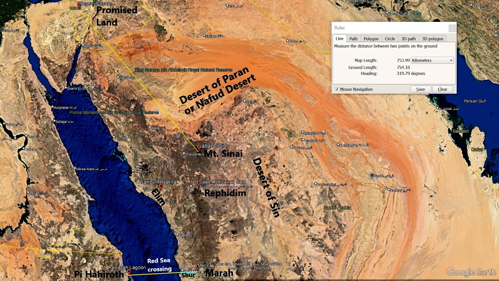
Pi Hahiroth is translated by the Strong’s concordance as both “mouth of the gorges'' or "place where sedge grows”. While sedges may be found growing in almost all environments, many are associated with wetlands like lagoons. Almost due east of Semna is located a wetland or lagoon named Dungunab Bay. Its mid part, the Rawayah Lagoon, is surrounded by coral reefs. I believe the Rawayah Lagoon is the Biblical Pi Hahiroth where the Israelis camped just before crossing the Red Sea. Also, both sedges and reeds are grass like plants, and according to Exodus 15:4 the place where Pharaoh’s choiced captains drowned was in the “sea of reeds” (Hebrew: Yam Suph). This implies they drowned near Pi Hahiroth or the Rawayah Lagoon from a tsunami which resulted when the massive side by side walls of water suddenly collapsed. In contrast, Pharaoh and the rest of his army drowned “into the sea” (Hebrew: bayyam), implying they died in the middle of the Red Sea.
Baal Zephon is translated by Strong’s concordance as "lord of the north". Inscriptions have shown that the name Ba'al was particularly associated with the storm and fertility god Hadad and his local manifestations. God instructed the Israelites to encamp by the sea directly opposite Baal Zephon and curiously enough, Mecca, where the famous Kaaba is built, is located almost due east of the Rawayah Lagoon, or the Pi Hahiroth! Note also that Hadad was originally worshiped in Canaan and ancient Mesopotamia both of which were located north of Mecca, thus literally making him the "lord of the north".
Prior to Islam, the Kaaba was a holy site for the various Bedouin tribes throughout the Arabian Peninsula. Once every lunar year, Bedouin people would make a pilgrimage to Mecca. Setting aside any tribal feuds, they would worship their gods in the Kaaba and trade with each other in the city. Various sculptures and paintings were held inside the Kaaba. A statue of Hubal (the principal idol of Mecca) and statues of other pagan deities are known to have been placed in or around the Kaaba.
I believe Hadad and Hubal are one and the same god. Hadad was the storm and rain god in the Canaanite and ancient Mesopotamian religions. While several scholars assert that Hubal was a god of rain and a warrior god. Shamash (a Sumerian sun god) and Hadad became in combination the gods of oracles and of divination in general, while Hubal's idol was a human figure believed to control acts of divination.
According to Islamic opinion, the Kaaba was the first House of Worship for mankind, and that it was built by Abraham and Ishmael. Later in this video I will show Biblical proof for this. What this means is that the Kaaba predated Moses and was most certainly extant during the Exodus. In my previous video titled “Exodus - Ice Bridge & Icy Meteors explain the parting & drying of the Red Sea!” I explained how the Israelites were able to miraculously cross the Red Sea coming from Pi Hahiroth towards Baal Zephon.
Exodus 15: 22-25 Then Moses led Israel from the Red Sea and they went into the Desert of Shur. For three days they traveled in the desert without finding water. When they came to Marah, they could not drink the water because it was bitter. (That is why the place is called Marah.) So the people grumbled against Moses, saying, “What are we to drink?” Then Moses cried out to the Lord, and the Lord showed him a piece of wood. He threw it into the water, and the water became fit to drink.
The next station stop of the Exodus was the Desert of Shur which is closely associated with the bitter water of Marah. Hagar, the Egyptian wife of Abraham was also associated with a spring of water in the Desert of Shur:
Genesis 16: 7-10 The angel of the Lord found Hagar near a spring in the desert; it was the spring that is beside the road to Shur. And he said, “Hagar, slave of Sarai, where have you come from, and where are you going?” “I’m running away from my mistress Sarai,” she answered.
In Islamic tradition, the civilization of Mecca started after Abraham left his son Ishmael and wife Hagar in the valley. When their provisions were exhausted, Hagar eventually ran out of food and water and could no longer breastfeed Ishmael. She thus ran back and forth seven times between two small hills named Safa and Marwah hoping to find water. Angel Gabriel came to their aid and a spring of water appeared from the ground. The well was named Zamzam and the journey back and forth between Safa and Marwah was made a ritual during Hajj. I believe the Islamic Marwah is one and the same as the Biblical Marah where a formerly bitter water (now known as Zamzam) flowed. Both Marwah and the well of Zamzam are located in Mecca near the Kaaba. I also believe the well of Zamzam is one and the same as the well of Beersheba mentioned in Genesis 21: 22-33 where Abraham planted a tree called ay'-shel in Hebrew. The piece of wood of this dead tree was what Moses threw in Marah to remove its bitterness.
Note that the Hebrew Biblical script (which omits vowels) for Marah is written Mem Resh He, and while it is currently pronounced Marah, it could have been pronounced as Maruh instead during the time of Moses. The Arabic Quranic script for Marwah (which also omits vowels) is written Mim Rah Waw Ha. However Waw can be pronounced as the vowel U if a vowel marking called damma appears above the preceding consonant. But just like Hebrew, vowels and vowel markings were not written in the Quran, so that while Marwah is the common pronunciation nowadays, it could have been pronounced as Maruh instead during the time of Muhammad just like its Hebrew counterpart.
Jeddah is the principal gateway coming from the Red Sea to Mecca, the hoIiest city in Islam, just 65 kilometers to the southeast. Now two locations of inter-mountain dune fields east and southeast of Jeddah were identified. This means the southeast road from Jeddah (The Biblical Shur) towards Marwah in Mecca (the Biblical Marah) is covered by sand dunes or desert. And according to Exodus 15: 22-25, it took the Israelites three days' journey to traverse the 65 kilometers Desert of Shur (or Jeddah), which I think is a reasonable pace.
After reaching Marah, the Israelites traveled to Elim where there were twelve springs and seventy palm trees, and they camped there near the water - see Exodus 15: 27. Yanbu (which literally means “spring” in Arabic) is approximately 351 kilometers northwest of Mecca. Yanbu has three primary sections, one of which is Yanbu Al-Nakhal (which literally means “the spring of the palms”). It is a city known for its springs. Yanbu was historically known as Charmutha, which is a small peninsula located to the north of Yanbu and was an ancient harbor and one of the most renowned ports of antiquity. It was large enough to accommodate 2,000 boats.
When Moses fled Egypt and crossed the Red Sea to live in Midian (see Exodus 2: 11-15), he must have boarded one of the boats traversing between Egypt and Charmutha. Thus I believe, the Biblical Elim was the port city of Yanbu Al-Nakhal where Moses was familiar with the path leading from Elim to Mount Sinai in Midian. In part 2 of this video, I will identify the next stations of the Exodus, namely, the Desert of Sin, Rephidim, Mount Sinai, & the Desert of Paran.

Comments
Post a Comment